(Part 2, Chapter 9, Section 2) ( Bk. Index )
The following transcript is from the WSRO apportionment.
Tithing of Ham and Bargham in Angmering
[Summary of preamble]
I Francis O Martin an Assistant Tithe Commissioner ....Whereas I have held a meeting in the parish of Angmering ... for the purpose of awarding a Rent Charge ...for Ham and Bargham...
whereas I find ... said district comprises 1264 acres 0r 12p
865 acres 2rood 7perches in Bargham, remainder in Ham [398a 2r 5p]
3 acres in Bargham ... are Glebe land and exempt by prescription from Tithes...
of the remaining lands in Bargham, 154a 0r 1p of grass land are covered from payment of Tithes .. by a certain ancient modus ... of 10/- payable at Michaelmas each year
the rest of the lands in the tithing are subject to ... all manner of Tithes as follows:-
399 a 0r 16p arable
170a 3r 2p pasture and Down
35a 2r 9p furze
98a 0r 15p plantation parks and pleasure grounds
3a 0r 22p sites of buildings
1a 3r 22p waste
lands in Ham subject to Tithes
186a 1r 1p arable
140a 0r 32p pasture
52a 1r 0p brooks
3a 1r 4p withey beds
16a 2r 8p gardens waste water roads
Revd Richard Bingham, Canon, Prebendary of Ham and Bargham, Chichester, is the owner in the right of his said Canonry a Prebend of said modus of 10/- and of all manner of Tithes ...
W.G.K. Gratwicke of Ham... by virtue of a lease of 3 lives ... is a joint owner with the Prebendary of the said modus and Tithes
£253 5s 0d Rent charge to W.G.K. Gratwicke during lease and afterwards to Prebendary
25th June 1849
[End of Preamble]
References & Notes
Ham Tithing WSRO: IR/29 35/122
Map WSRO: IR/30 35/122 by Henry Salter of Arundel 1847
(1) It should be noted that PRO, and other copies of the tithe maps for Angmering vary in slight detail.
(2) The 1847 Ham map is no doubt a copy from the original Angmering map of 1839, and a cottage is missing on the later map, either by mistake or it was demolished.
(3) Maps are diagramatic only and not to scale.
RWS 19/3/2009
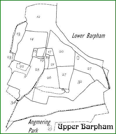
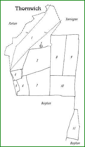
Thomas Duke tenant of Norfolk at Upper Barpham - Thornwick (see Map 1)
| Tenant | Plot |
Acres |
Usage |
Name |
| Duke Thomas | 1 |
137.71875 | (nil) |
The Down |
| Duke Thomas | 2 |
0.2625 | barn |
Barn & Yard |
| Duke Thomas | 3 |
42.125 | a |
Forty two Acres |
| Duke Thomas | 4 |
9.8 | a |
Thornwick Field |
| Duke Thomas | 5 |
3.39375 | (nil) |
Thornwick Copse |
| Duke Thomas | 6 |
12.9625 | a |
Coppice Field |
| Duke Thomas | 7 |
38.19375 | a |
Forty Acres |
| Duke Thomas | 8 |
40.6125 | a |
Upper Forty Acres |
| Duke Thomas | 9 |
36.925 | a |
36 Acres |
| Duke Thomas | 10 |
35.50625 | a |
35 Acres |
| Duke Thomas | 11 |
17.5 | a |
part of 19 Acres |
| . | Total |
375 | . |
. |
MAP 1
Thornwick
Thomas Duke tenant to Duke of Norfolk
Area directly north of Upper Barpham
Transferred to Burpham in 1933
Charles Hersee tenant of Norfolk at Upper Barpham (see Map 2)
| Tenant | Plot |
Acres |
Usage |
Name |
| Hersee Charles | 12 |
49.2813 |
down |
Part of Down |
| Hersee Charles | 13 |
10.7 |
a |
Side Hill Piece |
| Hersee Charles | 14 |
29.675 |
a |
Great Moat & 17 Acres |
| Hersee Charles | 15 |
1.7375 |
grass |
Crooked Croft |
| Hersee Charles | 17 |
1.9688 |
g |
Orchard |
| Hersee Charles | 18 |
2.8875 |
house |
Upper Barpham Farm House outbs yards garden driftway |
| Hersee Charles | 19 |
0.1 |
barn |
Barn & Yard |
| Hersee Charles | 20 |
25.4375 |
a |
Hill Field |
| Hersee Charles | 21 |
3.9938 |
g |
Well Croft |
| Hersee Charles | 22 |
2.8188 |
a |
Little Moat |
| Hersee Charles | 23 |
1.7 |
down |
Part of Down |
| Hersee Charles | 25 |
31.2063 |
a |
Barn Field & Cottage Field |
| Hersee Charles | 26 |
15.175 |
a |
Lower Cow Field |
| Hersee Charles | 27 |
12.9375 |
a |
12 Acres |
| Hersee Charles | 28 |
21.1438 |
a |
Plantation Field |
| Hersee Charles | 32 |
34.1813 |
a |
Oak Copse Field & Slip |
| Hersee Charles | 34 |
0.3 |
house |
Cottage & Garden |
| . | Total |
245.2438 |
. |
. |
MAP 2
Upper Barpham
Charles Hersee tenant of Duke of Norfolk
North of Angmering Park
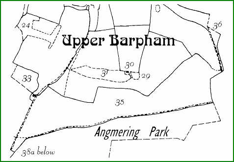
Norfolk in hand Upper Barpham (see Map 3)
| Tenant | Plot |
Acres |
Usage |
Name |
| Norfolk Duke of | 24 |
5.41250 |
wood |
Part of Dills Field Coppice |
| Norfolk Duke of | 29 |
0.55625 |
wood |
Part Coppice |
| Norfolk Duke of | 31 |
5.69375 |
wood |
Part Coppice |
| Norfolk Duke of | 30 |
0.13750 |
house |
Cottage & garden |
| Norfolk Duke of | 33 |
4.54375 |
wood |
Oak Field Coppice |
| Norfolk Duke of | 35 |
68.01875 |
wood |
Oak Coppice and Barpham Wood |
| Norfolk Duke of | 38a |
2.23750 |
wood |
Plantation |
| Norfolk Duke of | 36 |
1.79375 |
wood |
Plantation |
| . | Total |
88.39375 |
. |
. |
MAP 3
Upper Barpham
Duke of Norfolk woodland in his own hands
North of Angmering Park
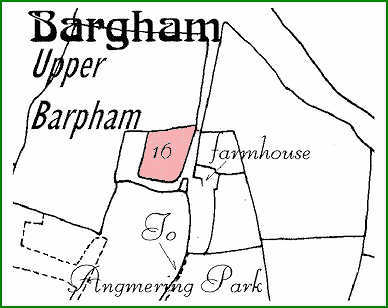
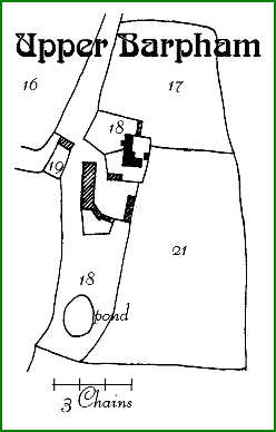
Glebe at Upper Barpham owned by WGK Gratwicke (see Map 4)
| Tenant | Plot |
Acres |
Usage |
Name |
| Hersee Charles | 16 |
2.8375 |
g |
Chapel Croft |
MAP 4
Glebe at Upper Barpham
owned by WGK Gratwicke
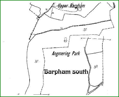
Thomas Meetings tenant of Norfolk in Angmering Park (see Map 5)
| Tenant | Plot |
Acres |
Usage |
Name |
| Meetings Thomas | 37 |
. | (nil) |
Part of Park |
| Meetings Thomas | 38 |
. | (nil) |
Part of Park |
MAP 5
Upper Barpham in Angmering Park
George Olliver in 1839 according to Angmering tithing map
Thomas Meetings in 1849 according to Ham and Barpham map
Tenants to Duke of Norfolk
Gratwicke owner of land in Ham (see Map 6)
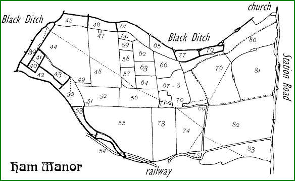
Ham Manor
Plot |
Acres |
Usage |
Name |
53a |
0.1250 |
rail |
railway |
54a |
0.5375 |
rail |
railway |
55a |
1.7188 |
rail |
railway |
73a |
0.2063 |
rail |
railway |
74a |
0.0313 |
rail |
railway |
39 |
6.2188 |
g |
Poling Bridge Field |
40 |
1.2375 |
ozier |
Square Ozier Bed |
41 |
1.5688 |
g |
Square Brook |
42 |
5.3563 |
g |
Norway Corner Brook |
43 |
4.7625 |
g |
Horse Brook |
44 |
30.5875 |
a |
Poling Bridge Field |
45 |
4.6875 |
g |
Lanes Brook |
46 |
4.1813 |
g |
New Barn Brook |
47 |
0.1188 |
fb |
barn and yard |
48 |
24.7625 |
a |
New Barn Field |
49 |
0.6313 |
furze |
Furze |
50 |
6.0813 |
g |
Rustington Bridge Brook |
51 |
0.1313 |
fb |
barn and yard |
52 |
10.3125 |
g |
Lower West Field |
53 |
3.1750 |
g |
Long Brook |
54 |
1.7813 |
ozier |
Lower Ozier Bed |
55 |
35.9625 |
a |
Salt and Leat Field |
56 |
10.6750 |
g |
West Field |
57 |
4.1875 |
g |
Foot Road Paddock |
58 |
3.3000 |
g |
Square Paddock |
59 |
2.0250 |
g |
Copse Paddock |
60 |
1.6688 |
wood |
Plantation |
61 |
5.9063 |
g |
Lay Field Brook |
62 |
5.0063 |
g |
North Paddock |
63 |
4.2875 |
g |
Middle Paddock |
64 |
4.1438 |
g |
South Paddock |
65 |
4.3063 |
g |
Hogg Brook |
66 |
6.9125 |
g |
Pond Paddock |
67 |
0.8625 |
g |
Paddock |
68 |
7.8875 |
house |
Mansion grounds cottage |
69 |
1.7438 |
road |
road and pond |
70 |
1.1063 |
g |
Paddock |
71 |
0.7813 |
house |
Cottage barns etc |
72 |
2.5000 |
g |
Croft and road |
73 |
17.4125 |
a |
South Field |
74 |
18.1625 |
a |
Step Stile Field |
75 |
1.0188 |
road |
Furze and old road |
76 |
35.0750 |
g |
North Field |
77 |
3.3563 |
g |
North Field Brook |
78 |
1.9125 |
wood |
Plantation in park |
79 |
2.4125 |
g |
North Field Brook |
80 |
20.4625 |
g |
The Steyne |
81 |
29.2313 |
g |
Milburrow |
82 |
41.9938 |
a |
East Field |
83 |
14.9938 |
a |
East Field |
84 |
0.1313 |
fb |
barn and yard |
85 |
0.0375 |
house |
cottage |
86 |
0.1250 |
houses |
two cottages |
87 |
0.2625 |
wood |
Jerusalem plantation |
88 |
0.4438 |
wood |
Jerusalem plantation |
89 |
0.0250 |
wood |
Jerusalem plantation |
MAP 6
Ham Manor
WGK Gratwicke owned land
West of Station Road
Mansion house at 67-8
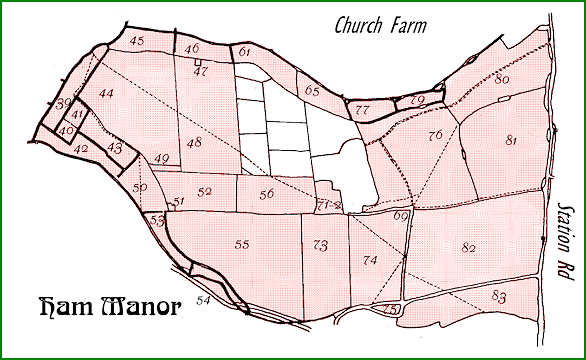
JW Heasman tenant of Gratwicke in Ham (see Map 7)
Ham Manor
| Owner | Plot |
Acres |
Usage |
Name |
| Gratwicke WGK | 39 |
6.21875 |
g |
Poling Bridge brook |
| Gratwicke WGK | 40 |
1.2375 |
ozier |
Square Ozier bed |
| Gratwicke WGK | 41 |
1.56875 |
g |
Square brook |
| Gratwicke WGK | 42 |
5.35625 |
g |
Norway Corner brook |
| Gratwicke WGK | 43 |
4.7625 |
g |
Horse Brook |
| Gratwicke WGK | 44 |
30.5875 |
a |
Poling Bridge field |
| Gratwicke WGK | 45 |
4.6875 |
g |
Lanes brook |
| Gratwicke WGK | 46 |
4.18125 |
g |
New Barn Brook |
| Gratwicke WGK | 47 |
0.11875 |
barn |
Barn Shed & Yard |
| Gratwicke WGK | 48 |
24.7625 |
a |
New Barn Field |
| Gratwicke WGK | 49 |
0.63125 |
furze |
Furze |
| Gratwicke WGK | 50 |
6.08125 |
g |
Rustington Bridge brook |
| Gratwicke WGK | 51 |
0.13125 |
barn |
Barn & Yard |
| Gratwicke WGK | 52 |
10.3125 |
g |
Lower West Field |
| Gratwicke WGK | 53 |
3.175 |
g |
Long Brook |
| Gratwicke WGK | 54 |
1.78125 |
ozier |
Long Ozier bed |
| Gratwicke WGK | 55 |
35.9625 |
a |
Salt & Leat Field |
| Gratwicke WGK | 56 |
10.675 |
g |
West Field |
| Gratwicke WGK | 61 |
5.90625 |
g |
Lay Field brook |
| Gratwicke WGK | 65 |
4.30625 |
g |
Hogg Brook |
| Gratwicke WGK | 71 |
0.78125 |
house |
Cottage & garden barns yards & farm build. |
| Gratwicke WGK | 72 |
2.5 |
g |
Croft & Road |
| Gratwicke WGK | 73 |
17.4125 |
a |
South Field |
| Gratwicke WGK | 74 |
18.1625 |
a |
Step Stile Field |
| Gratwicke WGK | 75 |
1.01875 |
furze |
Furze & Old Road |
| Gratwicke WGK | 76 |
35.075 |
g |
North Field |
| Gratwicke WGK | 77 |
3.35625 |
g |
North Field brook |
| Gratwicke WGK | 79 |
2.4125 |
g |
North Field brook |
| Gratwicke WGK | 80 |
20.4625 |
g |
The Steyne |
| Gratwicke WGK | 81 |
29.23125 |
g |
Milburrow |
| Gratwicke WGK | 82 |
41.99375 |
a |
East Field |
| Gratwicke WGK | 83 |
14.99375 |
a |
East Field south |
| Gratwicke WGK | 84 |
0.13125 |
barn |
Barn yard & hovel |
| Gratwicke WGK | 85 |
0.0375 |
house |
Cottage & garden |
| Gratwicke WGK | 86 |
0.125 |
houses |
Two Cottages and gardens |
| TOTAL | . |
350.1375 |
. |
. |
| . | . | . | . | . |
| Two and half acres in addition was owned by the Railway [Ham tithe map is post rail building] | ||||
MAP 7
Ham Manor
Heasman tenant of WGK Gratwicke
West of Station Road
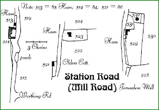
Some small plots and cottages in Station Road cannot be clearly identified on the above Ham tithing map. There are also cottages at Barpham not clearly identifiable on those maps. Larger detail maps of those houses/cpttages are therefore provided below.
MAP 8
Upper Barpham
Farmhouse and Buildings
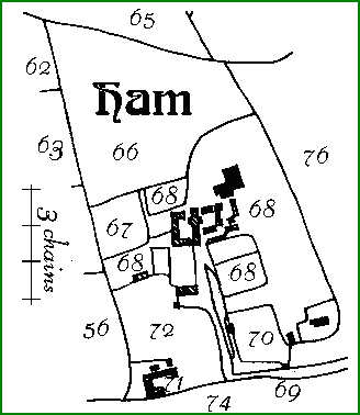
MAP 9
Ham Manor
Manor House with Cottages and Buildings
MAP 10
Ham Manor
Cottages and Buildings in Station Road
These are from the Angmering Map
513 is 85; 514 is 84; 521 is 86, in the Ham Schedule
RWS 23/3/2009
Introduction to Tithes & Commutations
Key Maps
Angmering Apportionments